6.1 Richter Scale Earthquake Shakes Indonesia’s Maluku Province, Triggers Rush to Higher Ground

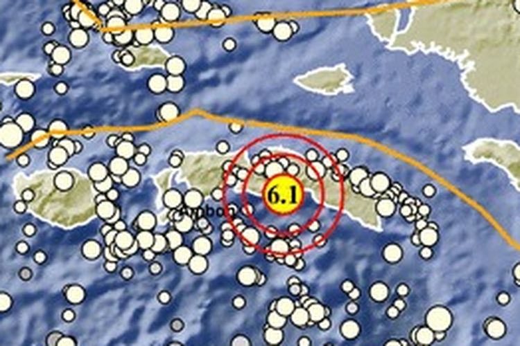

KOMPAS.com – A 6.1 Richter Scale earthquake has shaken the eastern Indonesian province of Maluku on Wednesday. No casualties were reported in the natural disaster, which struck the island of Seram in the province’s Central Maluku Regency.
The Meteorology, Climatology and Geophysics Agency or BMKG said the earthquake occurred at a depth of 19 kilometers, 69 kilometers off the town of Masohi in Seram.
“The tremors are classified as a shallow earthquake,” said BMKG Earthquake and Tsunami center head Bambang Setiyo Prayitno MSi.
Also read: Earthquake in Indonesia's East Java Province Kills Eight, Injures 25
“The tremors were felt in Masohi and the nearby districts of Tehoru, Bula, Kairatu, Saparua, and Wahai.”Bambang added that 13 aftershocks averaging 3.5 Richter scale occurred in the wake of the earthquake.
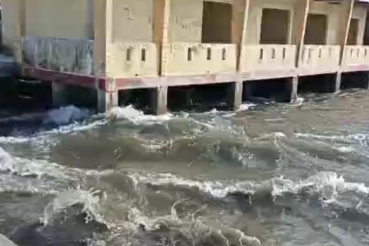
“As a shallow earthquake, the earthquake will not theoretically cause a tsunami. However, the Tehoru Tide Gauge detected a 0.5 meter rise in water levels,” he maintained.“We deduce that [the rising waters] are caused by underwater landslides.
 The village of Tehoru in Maluku Province's Central Maluku Regency was hit by high tides, among them a fast flowing tsunami, following a shallow 6.1 Richter scale earthquake on Wednesday, (16/6/2021)
Bambang asserted that the underwater landslides are cause for concern. “I urge people who live on the shores of Japutih Beach to Atiahu Beach to beware of aftershocks and tsunamis caused by underwater landslides or those on the surface,” he said.
“They should avoid the beach and head for higher ground if they felt the earthquake. The BMKG will continue to monitor for aftershocks and its effects on the seas.”
Also read: 6.2 Richter Scale Earthquake Strikes East Java, Other Indonesian Provinces
However, BMKG Regional head for Maluku Herlambang Hudha maintained a tsunami did occur. "The tsunami emerged from two minutes after the earthquake. It passed very quickly," he said.
Maluku governor Murad Ismail urged the inhabitants of Seram to remain on guard, following the BMKG warning on aftershocks and potential tsunamis. Central Maluku Regent Tuasikal Abua reiterated Murad, as he urged the locals to move to safer ground inland.
Assessing the damage
Among the villages that were hardest hit by the earthquake was Tehoru.
“The earthquake damaged up to 40 houses in Tehoru. These include 19 houses in the Mahu hamlet, 12 houses in Pasalulu hamlet, and nine houses in Tehoru itself,” said Tehoru village secretary Subhan Kinlihu.
The BMKG also "urged the inhabitants to remain calm and ignore unsubstantiated rumors. We also call on them to avoid any buildings and other structures damaged by the earthquake,” the Agency said.
More Headlines


Taiwan's Semiconductor Industry: A Rising Powerhouse with Global Impact


3 Malaysian Nationals Missing after Boat Capsizes Near Indonesia’s Side of Borneo


Indonesia to Deploy Warships during ASEAN Summit in East Nusa Tenggara


Jakarta High Court Rejects Appeal of Ex-Police General Ferdy Sambo Facing Death Sentence


Indonesia Religious School Principal Named Suspect in 14 Students' Sexual Abuse


Centuries-old Indonesian Easter Tradition Returns after Pandemic Hiatus